
Stedlyn Retreat Archaeological Summary Report (published 2004)
-- Associated with the Macey family; this plot was latterly developed as St Pauls Court --
'An archaeological evaluation and subsequent excavation and watching brief were carried out by Wessex Archaeology in advance of the housing development at 'Stedlyn' (St Paul's Court). Here are the reports on the work. For more information on Sir Dru Drury and his times, see Selby, E, Teynham Manor and Hundred, Meresborough Books, 1982. Thanks are due to Wessex Archaeology for permission to publish the reports.'
The parish council has a hard copy (via Swale BC) and plan to put a piece based on the summary, in the Parish NewsLetter.
In brief:
The First Report: describes two excavation areas that were opened which targeted archaeological features revealed during an archaeological evaluation undertaken at the Site in August 2004.
The Second Report: was commissioned as an archaeological watching brief during machine excavation of a cable trench. Despite recent archaeological evidence close to the cable trench location, no significant archaeological remains were identified during this watching brief.
More recent history includes a stint as a greyhound dog-track, training and breeding kennels. Read about that history from records of the Macey Family.
The First Report: Summary Of Excavation Results And Assessment Of Potential For Analysis And Publication. Ref: 58670.03 April 2005
| 1. Introduction - 1.1 Project Background - 1.2 The Site: Location, Topography and Geology |
9. Discussion |
| 2. Archaeological and Historical Background | 10. Objectives of Analysis and Report Preparation - 10.1 Introduction |
| 3. Aims and Objectives | 11. Proposed Reporting |
| 4. Excavation Strategy | 12. Management Structure and Quality Assurance - 12.1 Project Team |
| 5. Excavation Methodology | 13. Project Tasks - 13.1 Introduction - 13.2 Key to Staff Grades |
| 6. Results - 6.1 Introduction - 6.2 Area 1 (Figure 2) - 6.3 Area 2 (Figure 3) |
14. Programme for Post Excavation Analysis - 14.1 Programme |
| 7. Finds - 7.1 Introduction -- Table 1: All finds by context (number/ weight in grams) -- Layer -- Med/Pmed pottery -- Metal - 7.2 Pottery - 7.3 Ceramic Building Material - 7.4 Animal Bone -- Condition and preservation -- Later Prehistoric -- Medieval/Post-Medieval - 7.5 Other Finds - 7.6 Recommendations for the Whole Finds Assemblage |
15. Archive Storage and Curation - 15.1 Museum - 15.2 Storage - 15.3 Discard Policy - 15.4 Copyright - 15.5 Security Copy 16. Bibliography 17. Internet References
|
| 8. Environmental Assessment - 8.1 Aims - 8.2 Samples Taken and Palaeo-Environmental Evidence - 8.3 Assessment Results; Methods and Data -- Introduction -- Charred plant remains -- Charcoal -- Land molluscs - 8.4 Potential Charred plant remains and Charcoal Land snails - 8.5 Palaeo-Environmental Summary Proposals |
Appendix 1
Figure 1 Site location plan showing original evaluation results Figure 2 Detail of Area 1 Figure 3 Detail of Area 2 |
Millwood Designer Homes commissioned Wessex Archaeology, to carry out an archaeological excavation on land at Stedlyn Retreat, Lynsted, Kent. Two excavation areas were opened which targeted archaeological features revealed during an archaeological evaluation undertaken at the Site in August 2004.
Area 1 revealed two early to mid 17th century walls forming a right angle, which are the footings for what is most likely a garden wall or surrounding boundary wall. This wall possibly represents the remains of structures associated with the former mansion of Sir Dru Drury, a Gentleman Usher at the coronation of Queen Elizabeth I, Member of Parliament and Lieutenant of the Tower of London. Only the foundations of this wall survive to any great extent, showing that extensive robbing of material has occurred, possibly when the mansion was demolished. It is however, possible that the wall was constructed following the demolition of the mansion, some time around 1643, and is the remains of the boundary wall of the property and building which replaced it.
 Area 2 revealed a number of Late Iron Age ditches which are probably the remains of field systems, associated with a small farmstead located somewhere to the north of the area. No structures or other deliberately cut features associated with the Iron Age field systems were revealed.
1 INTRODUCTION
1.1 Project Background
1.1.1 Wessex Archaeology was commissioned by Millwood Designer Homes Ltd (the Client), to undertake an archaeological excavation on the land at Stedlyn Retreat, The Street, Lynsted, Kent (hereafter 'the Site') centred on NGR 594360 160875. The excavation was carried out in accordance with a Project Design (Wessex Archaeology 2004b) requested by the Local Planning Authority (LPA), Thanet District Council on the advice of Kent County Council's Archaeological Officer following the completion of an archaeological evaluation in July 2004 (Wessex Archaeology 2004a). The Project Design set out the methodologies and standards to be employed for the undertaking of targeted excavations of areas of archaeological potential identified from the evaluation.
1.1.2 Two areas comprising a total of 577 square meters were the subjects of archaeological excavation. These areas were targeted upon the positions of features identified within Trenches 3 and 6 of the evaluation (Wessex Archaeology 2004a).
1.1.3 The Site has been granted planning consent by the LPA, Thanet District Council (no. SW/02/1143) for the construction of 25 new dwellings, with associated landscaping, services and access, subject to the completion of the archaeological investigations.
1.2 The Site: Location, Topography and Geology
1.2.1 The Site was bounded to the west by The Street and by private residencies fronting on to it, to the north and east by open space, predominately fields and to the south by a brook. The Site had been recently cleared of a number of buildings and areas of hard standing relating to structures were present at the evaluation stage.
1.2.2 The topography of the Site was generally flat, lying at between 42m and 46m above the Ordnance Datum (aOD), although it was observed to drop away sharply towards the brook in the south to c. 37.5m aOD.
1.2.3 The underlying geology of the Site is Upper Chalk, although the Site lies at the interface between the Upper Chalk and the London Clays of the Swale (BGS Solid & Drift Edition Sheet 274, 1:50 000).
2 ARCHAEOLOGICAL AND HISTORICAL BACKGROUND
2.1.1 The Site lies within an area of moderate archaeological potential. The village of Lynsted contains a number of Listed Buildings, some of which date to the medieval period (1066-1539).
2.1.2 Situated on the opposite side of The Street to the Site is the parish church of St. Peter and St. Paul, which is Grade I Listed. It dates from the 14th century, although it is known to retain some 13th century elements. The chancel was rebuilt in the 16th century, with the whole structure restored during the 19th century.
2.1.3 A further two medieval buildings lie to the south of the church, Heathfield and Anchor House. Both are Grade II Listed Buildings and both are in use as private residences. An additional Listed building, the Old School House, lies immediately north of the Site.
2.1.4 The area of proposed development is believed to have been the site of Sir Dru Drury's mansion. Born c. 1532, Sir Dru served as a Gentleman Usher at the coronation of Queen Elizabeth I, as a Member of Parliament and as a Lieutenant of the Tower of London. Sir Dru's role as Usher is likely to have arisen from his first marriage to Elizabeth, daughter and heir of Sir Philip Calthorpe of Cockthorpe, Norfolk. Elizabeth's mother was an Aunt of Anne Boleyn and so Sir Dru, by marriage had become a relation of the Royal House, and the close connection of his mother-in-law to Queen Elizabeth's mother led to him becoming a loyal and trusted member of the Royal household. (Internet Reference A)
2.1.5 Sir Dru was so trusted by Queen Elizabeth that he along with Sir Paulet was given the assignment of the arrest of Mary Queen of Scots. Sir Dru was later sent to Fotheringhay castle to assist in the Wardership of Mary and was thus subsequently a witness at her execution in 1587. (Internet Reference B)
2.1.6 Sir Dru Drury's only son, also Sir Dru (born c.1586/88) is credited with the demolition of his father's mansion on the Site according to local tradition, with the demolished material being used for the expansion of the house 'Beaugill' within the village. It is suspected that the date of demolition is around 1643, as this reflects the date which appears on the extension to Beaugill (Internet Reference D). If this is the case, it is likely to have been Sir Dru's grandson, also Sir Dru (b.1611/12, d.1651, Internet Reference A), who ordered the demolition.
2.1.7 The original mansion is believed to have grown too small for the Drury family and so they moved to Beaugill following the extensions to the Tudor house with the reuse of material from the original house. Beaugill passed out of the Drury family to the Hugessens sometime before 1648, when the Hugessens are recorded in Lynsted as prominent Royalists during the Civil War. (Internet Reference C)
2.1.8 To the south of the Site lay the former location of a post-medieval icehouse demolished in 1925.
2.1.9 The 1st edition Ordnance Survey shows the Site to comprise mainly open ground whilst by the 4th edition the Site is completely covered by trees, possibly representing orchards.
2.1.10 The Site was in use as a greyhound racing circuit until the 1970s, and continued in use as kennels up until recently
3 AIMS AND OBJECTIVES
3.1.1 The aims of the excavation were to expand upon the information obtained from the evaluation and so determine, as far as reasonably possible the location, extent, date, character, condition, significance and quality of any surviving archaeological remains, related to those already identified that may be affected by the proposed development.
3.1.2 All archaeological features and deposits were to be preserved by record.
4 EXCAVATION STRATEGY
4.1.1 The Project Design (Wessex Archaeology 2004b) stated that initially two areas of excavation were to be opened, targeted upon the archaeology identified in Trenches 3 and 6 from the evaluation. Once these areas had been cleaned and examined a meeting was held on Site attended by the Wessex Archaeology Project Manager, the Principal Archaeologist for K.C.C. and the Client to discuss the need and appropriateness of further investigations. No further investigations were required.
5 EXACAVATION METHODOLOGY
5.1.1 The location of each area of excavation had been swept using a cable avoidance tool (CAT) prior to excavation using a 360°tracked excavator equipped with 1.8m wide toothless ditching bucket. Excavation proceeded in spits under constant archaeological supervision to the top of the archaeological deposits or to the top of the underlying basal geology. Each area was then hand cleaned and all potential features and structures investigated.
5.1.2 All features and structures revealed were investigated and each area recorded using Wessex Archaeology's pro forma recording sheets. A drawn record was produced which included a plan of Area 1 and individual feature plans of features in Area 2 at 1:20, and feature sections at 1:10. Area 2 was planned using a Leica GPS 1200 system.
5.1.3 A full photographic record was also maintained which included colour transparencies, black and white negatives and digital images. The photographic record illustrated both the detail and general context of the archaeology revealed and the Site as a whole.
5.1.4 The two areas of excavation were surveyed using a Leica GPS 1200 system and tied to the Ordnance Survey National Grid, with OD heights of all principle features and levels calculated and plans and sections annotated with OD heights.
6 RESULTS
6.1.1 Below is a summary of the results of the excavation. More detailed records of each area are presented in Appendix 1. The locations of the areas of excavation are illustrated in Figure 1, with further detail in Figure 2 and Figure 3.

Site Plan
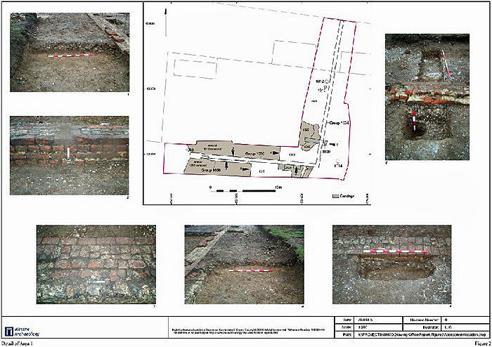
6.2 Area 1 (Figure 2)
6.2.1 Area 1 measured some 256 sq. m. and was targeted upon an east-west aligned red brick wall, 310, originally identified in Trench 3 of the evaluation (Wessex Archaeology 2004a). The area formed an approximate 'L' shape.
6.2.2 Subsequent to the removal of 0.20m of turf and mid-dark brown topsoil (1000) and a further 0.05m of light brown silty clay subsoil (1001), the extent of the east-west wall was ascertained, along with a north-south aligned return at its eastern extent.
6.2.3 The earliest feature identified was a wall, group number 1038, comprising a facing of flint nodules within a pale grey mortar (1004), exhibiting a core of rubble and broken peg tile (1005). This is likely to be the foundations of an earlier wall, demolished prior to levelling and landscaping across the Site. Although identified as earlier than other features in Area 1, no firm dating evidence was recovered.
6.2.4 Subsequent to its demolition, 1038 was sealed by a levelling/landscaping deposit consisting of a compact layer of flint nodules and cobbles within a silt/clay/loam matrix. It was identified within several additional test pits excavated across Area 1 and recorded as 1017 (also 1034, 1025, 1018 and 1027) and could be seen to extend below the base of the walls 1035 and 1036. This deposit was recorded during the evaluation as context 303.
6.2.5 The digging of the foundation trenches for walls 1035 and 1036 subsequently cut through 1017. Foundation cut 1037 not only cut through 1017 but also truncated away the northern half of earlier wall 1038, which was sealed below it.
6.2.6 Due to the level of compaction of landscaping layer, 1017, it appears to have been prohibitively difficult to excavate foundation trenches through this flint rich layer. As a result, foundation trenches became shallower and subsequently 1017 acted as a foundation for newly constructed walls, which can be seen to rest directly upon this layer.
6.2.7 The date of the deposition of 1017 is unclear, although a single sherd of medieval pottery, dated to 1225-1375 was recovered from 1034. This sherd may, however be residual, as post-medieval ceramic building material (CBM) fragments were also recovered from 1027.
6.2.8 The east-west aligned wall group, 1036, extended for 17m from its open western extent to its eastern end, where it turned north (wall group 1035). The north-south section extended north for 22.2m, continuing beyond the northern limit of excavation. Traces of foundation material and a probable construction cut (1038) were identified at the western extent of 1036, indicating further walling northwards from this point.
6.2.9 It is likely that 1035 and 1036 formed a garden or boundary wall, as opposed to a building. There is no evidence for internal walls and it is clear the two walls do not form a right angle.
6.2.10 Both the foundations and areas of upstanding wall show evidence for the reuse of materials, with broken and whole bricks, broken and occasional whole peg tiles all in evidence. This apparently reused material has been dated to the post-medieval period, although no later than the 18th century. A number of photographs of areas of the structure are presented in Figure 2.
6.2.11 A number of additional features were revealed in Area 1. A single post-hole (1030) was revealed in a test pit excavated against the eastern side of wall 1028 (part of 1035). This contained post-medieval CBM and may have been related to the construction of the wall, possibly representing part of a scaffold, or may, alternatively, have represented part of an earlier boundary.
6.2.12 A post-hole (1014) was identified to the east of the intersection of the two walls. As with 1030, this feature was filled with post-medieval CBM.
6.2.13 Two modern post-holes (1010 and 1012) were also identified cutting deposit 1043.
6.3 Area 2 (Figure 3)
6.3.1 Area 2 measured some 321m²., and was targeted on an east-west aligned Late Iron Age ditch identified within Trench 6 of the evaluation.
6.3.2 The ditch (grouped as 2038) was identified during the evaluation where it was thought to turn to the north. However, further excavation within this phase of works revealed this not to be the case, instead recorded as running east-west for 25m, from its truncation by modern activity at its western end to its cutting by a later ditch group (2039) at its eastern extent.
6.3.3 Group 2038 had three interventions excavated along its length, revealing considerable truncation towards its western end, with 2018 being 0.18m deep, 2009 0.24m deep and 2019 0.50m deep. This truncation is assumed to be the result of modern activity.
6.3.4 Excavations along the ditch suggested there had been a long period of silting, with material derived from the feature's edges combined with more water borne material. Pottery recovered from fills 2020, 2017 and 2010 has been identified as Late Prehistoric, in some cases specifically Late Iron Age.
6.3.5 Further to natural silting events, a period of deliberate deposition of material occurred within the upper fills of the ditch, with charcoal-rich material, indicative perhaps of hearth clearances, and more general domestic waste identified.
6.3.6 A second ditch group, 2039, was identified. Aligned north-south, it apparently cut through the extreme eastern end of 2038, although sections excavated to investigate this relationship proved inconclusive. Pottery recovered from 2039 was of similar date to that from 2038 suggesting both features to have fallen into disuse at the same time.
6.3.7 A third section of ditch was identified to the north of 2038. Ditch group 2040 was aligned east-west and also dated to the Late Iron Age. Two sections were excavated through it which identified significant truncated by later, probably relatively modern activity
6.3.8 Several other features containing Late Iron Age material were identified. These included tree throws 2016, 2023 and 2031 and a possible pit, 2003. Tree throw 2016 truncated ditch 2038 (in the area of section 2018) whilst from within the fill of tree throw 2015, a rim sherd of Dressel 1A amphora was recovered; a type dated from the later 2nd to mid 1st century BC which represents is a rare find in Kent.
6.3.9 A number of post-medieval features were also identified within Area 2. These comprised a group of sub-square post-holes, possibly indicative of an east-west orientated boundary or structure.
6.3.10 In addition, the deliberate burial of a young goat was recorded within a small pit, 2006. A considerable amount of further modern disturbance and later truncation was identified in Area 2 with several large modern rubbish pits clearly visible. This truncation and the animal burial described above are likely to represent 20th century activity.
7 FINDS
7.1 Introduction
7.1.1 A small quantity of finds was recovered during the excavation, which augments the assemblage previously recovered from the evaluation of the site (Wessex Archaeology 2004a). As for the evaluation, most of the finds are of later Prehistoric date, but there is also a small group of medieval and post-medieval material.
7.1.2 All finds have been quantified by material type within each context, and this information is presented in Table 1.
| Context | Type | Description |
| 1000 | Topsoil | Current Turf and Topsoil. mid-dark brown silt, clay |
| 1001 | Subsoil | Light brown silty clay |
| 1002 | Natural | Light grey yellow silty clay wilt common patches of chalk and loge flint nodules. |
| 1003 | Wall | Component of Group 1036. |
| 1004 | Wall | Outer facing of Wall Group 1038 |
| 1005 | Wall Core | Wall core associated with 1004, component of Group of 1038. |
| 1006 | VOID | VOID |
| 1007 | layer | Single course of broken peg tile, at base of cut 1037. levelling for wall 1003 |
| 1008 | Wall | Component of Group 1036 |
| 1009 | Wall | Component of Group 1035 |
| 1010 | Cut | Modem Pos:-Hole |
| 1011 | Fill | Fill of Modem Post-Hole 1010 |
| 1012 1013 |
Cut Fill | Cut of Modem Post-Hole Fill of Modern Post-Hole 1012 |
| 1014 | Cut | Cut of Post-Hole |
| 1015 | Fill | Fill of Post-Hole 1014. contained 17' century brickwork |
| 1016 | Wall | Component of Group 1036 |
| 1017 | Layer | Large scale levelling and landscaping deposit which was partially cut through for construction of walls 1035 and 1036. and acted as foundation deposit. (Equal to 1034.1025,1018,1043,1027 |
| 1018 | Layer | Equal to 1017 |
| 1019 | Layer | Deliberate deposition of chalk, overlies 1027 (equal to 1018). levelling layer. |
| 1020 | Layer | Thin layer of chalk, which overlies 1023 |
| 1021 | Layer | Thin layer of chalk which overlies 1025 |
| 1022 | Layer | Layer of te-woikol natural which overlie: 1002 below 1034 |
| 1023 | Wall | Component of Group 1036 |
| 1024 | Wall | Component of Group 1036 |
| 1025 | Layer | Equal to 1017 |
| 1026 | Layer | Area of levelling that overlies 1019. |
| 1027 | Layer | Equal to 1017 |
| 1028 | Wall | Component of Group 1035 |
| 1029 | VOID | VOID |
| 1020 | Cut | Cut of Post-Hole adjacent to wall 1028, possible evidence of earlier alitmment |
| 1031 | Fill | Fill of Post-Hole 1030 |
| 1032 | VOID | VOID |
| 1033 | Cut | Cut of foundation trench for wall 1028 (component of 1035) |
| 1034 | Layer | Equal to 1017 |
| 1035 | Group for Wall | North-South aligned wan, composed of 1009 and 1028 |
| 1026 | Group for Wall | East-West aligned wall, composed of 1003, 1016, 1023, 1024,1008. |
| 1037 | Cut | Cut of foundation trend: for wall 1003 (component of 10361 |
| 1038 | Group for Wall | East-West aligned Wall, composed of 1004 and 1005 |
| 1039 | Cut | Cut of foundation trench for wall 1016 (component of 10361 |
| 1040 | Cut | Cut of foundation trend: for wall 1023 (component of 1036i |
| 1041 | Cut | Cut of lbuncatton trend: for wall 1024 (component of 10361 |
| 1042 | Cut | Cut of foundation trend for wall 1008 (component of 10361 |
7.2 Pottery
7.2.1 The majority of the pottery assemblage is of later prehistoric date, with a smaller quantity of medieval and post-medieval material.
7.2.2 Later prehistoric pottery was confined to Area 2, the largest group coming from 2017 the fill of ditch section 2018 (group 2038). Fabrics and forms echo those seen in the evaluation assemblage and dated as Middle to Late Iron Age – beaded and everted rim vessels (some cordoned) in flint-tempered, grog-tempered and glauconitic sandy fabrics with external surfaces frequently textured by combing, brushing or scoring. One rim sherd from a Dressel 1A amphora came from 2015 (fill of tree throw 2016); this is a type dating from to later 2nd to mid 1st century BC, and is a rare find in Kent, most known findspots being confined to central southern England (Fitzpatrick 2003, fig. 2).
7.2.3 Later pottery comprises a few sherds in sandy fabrics, mainly finewares of Tyler Hill (Canterbury) type, with a small group of post-medieval redwares from 1001, the subsoil of Area 1.
7.3 Ceramic Building Material
7.3.1 All of the ceramic building material is of post-medieval date. This includes fragments of bricks, all unfrogged types, some of them with vitrified surfaces and one (from subsoil 1001) distorted – either resulting from initial firing faults, or from use involving subjection to high temperatures (for example, in kiln structure). The other fragments are from roof tiles of medieval or, more likely, post-medieval date.
7.4 Animal Bone
Condition and preservation
7.4.1 In total, 464 animal bone fragments were recovered, and were dated by ceramic association to the later Prehistoric and the medieval/post-medieval period. Four bones were not dated, from two contexts comprising the landscaped open area. These include the heavily gnawed distal epiphysis of an immature large cattle femur, and the chopped remains of a large mammal pelvis, and these bones are not discussed further.
Table 2 - Condition of bone fragments
| Phase/Condition | Poor | Fair | Good | Excellent | Total |
| Later Prehistoric | 35 | 140 | 8 | 183 | |
| Medieval/Post medieval | 3 | 2* | 2 | 7 | |
| Undated | 2 | 1 | 3 | ||
| Total | 40 | 141 | 10 | 2 | 193 |
7.4.2 Bone survived in a generally in fair condition, with the goat skeleton very well preserved. Gnawing was uncommon and seen on only 9 bones overall, with the most extensive marks on the undated bones, while butchery marks were visible on 17 bones. 11 loose teeth were identified, most from ditch fill 2017, indicating that this deposit had suffered some reworking, and root disturbance had affected some of the bones but not enough to significantly impact on the bone surface. The bones are therefore unlikely to have been differentially preserved through chemical erosion but those more desirable to scavengers (e.g. proximal humerus, distal femur) could be under-represented (Stallibrass 1984).
Later Prehistoric
7.4.3 This material is mainly derived from ditch fills, although some was found in tree throws. 30% was identified to species, the majority being of cattle, with smaller numbers of sheep/goat and pig (Table 3). Fourteen bones could be aged, and most were skeletally mature or young adults at prime meat weight, although one very old sheep was indicated by a mandible with heavy tooth wear. A smaller number could be measured, consisting predominantly of the small slender animals typical of Iron Age Britain (Maltby 1986). Remains from a female pig and possibly castrated sheep were recovered. Trauma may have resulted in the slight exostosis and porosity on the anterior margin of a large mammal rib, while a very enlarged foramen in a large mammal lumbar vertebra could have been a physiological change caused by heavy labour.
Table 3: Number and species of proportions of later prehistoric animal bones
| Context | Cattle | Sheep/ Goat |
Pig | Unidentified | Total | Gnawed | Butchery | Measure | Age |
| NISP | 35 | 12 | 5 | 129 | 183 | 6 | 15 | 5 | 14 |
| % | 19 | 7 | 3 | 70 | 100 | 3 | 8 | 3 | 8 |
7.4.4 Butchery marks were frequently seen, and on cattle, included cut marks from decapitation, skinning and disarticulation, and chop marks from portioning meat-bearing bones and removal of the horn core. Sheep and pig bones displayed similar marks, although cut marks were relatively more common, and some helical fractures from breakage of fresh bone were recorded. No bones had been burnt.
7.4.5 Some differences in bone element were seen between the upper and lower fills of the ditch. The lower ditch fill contained a greater proportion of 'waste bones' such as skull and foot bone that contain relatively little meat, although some ribs and long bone fragments were present. The upper ditch fills contained a mixture of meat-bearing and 'waste' bones, but with a greater emphasis on the former, with scapulae from two individuals, femora and vertebrae as well as skull and lower limb bones. This could indicate different activities resulting in the two deposits, with the lower fill indicative of primary butchery waste and the upper with more of a mixture of meat and waste bones. However, the majority of bones in both were cattle, which are more likely to have been filleted than cooked on the bone, than smaller animals. In addition the bones from smaller animals were entirely 'waste' elements, so it is possible that the ditch served as a convenient repository for undesirable butchery waste, away from the main habitation area, as suggested by various authors (e.g. Wilson 1996; Maltby 1985).
Medieval/Post-Medieval
7.4.6 A single articulated goat had been buried in feature 2006. This individual was in good condition and most parts of the skeleton were present, with the exception of some very fragile or small bones (parts of the skull and third phalanges for example). The individual was approximately 63cm at the shoulder, and the bones were slender, typical of a female animal. Both bone fusion and tooth wear aged the animal to between two and a half and three years, using modern figures. Despite not being fully skeletally mature, pathological conditions had affected several bones, including a slightly swollen metatarsal shaft, ossification of tendon on the proximal metacarpal and crowded mandibular teeth. The long bones were very thin walled, and this may indicate nutritional stress. This animal was stratigraphically dated to the post-medieval period, and is very well preserved, and it is possible that this may be the remains of a relatively modern farm casualty.
7.4.7 Other bone dated to this period was scarce, consisting only of a cattle pelvis and two proximal metatarsals from two sheep, and a pig incisor with groove across the crown that may indicate a period of illness or vitamin deficiency in this individual's life.
7.5 Other Finds
7.5.1 Other finds comprise prehistoric worked flint (cores and flakes, residual in later contexts), burnt, unworked flint (uncertain date), a piece of worked limestone, possibly part of an ashlar, cockle and oyster shell, modern vessel glass, iron objects (nails, probably post-medieval).
7.6 Recommendations for the whole finds assemblage
7.6.1 Potential for gaining a clearer understanding of animal husbandry on the Site or the nature of the late prehistoric occupation on the Site through further analysis of the animal bone, pottery or other artefacts recovered during the evaluation and excavation phases, is limited by the relatively small size of the assemblage.
7.6.2 No further primary analysis is therefore recommended, but the characteristics of the assemblage noted in this report should be included in any publication with full references and parallels.
8 ENVIRONMENTAL ASSESSMENT
8.1 Aims
8.1.1 A small suite of samples were taken and assessed to indicate their potential to help interpret the Site's activities, economy and landscape.
8.2 Samples taken and palaeo-environmental evidence
8.2.1 A series of seven bulk samples of generally 10 litres, but varying between 9 and 12 litres, were taken from Late Iron Age ditches. These were processed for the recovery and assessment of charred plant remains and charcoal.
Categories of palaeo-environmental evidence:
- charred plant remains
- charcoal
8.3 Assessment Results; methods and data
Introduction
8.3.1 The bulk samples were processed by standard flotation methods; the flot retained on a 0.5 mm mesh and the residues fractionated into 5.6 mm, 2 mm and 1 mm fractions and dried. The coarse fractions (>5.6 mm) were sorted, weighed and discarded.
8.3.2 The flots were scanned under a x10 - x30 stereo-binocular microscope and presence of charred remains quantified (Table E1.) to record the preservation and nature of the charred plant and charcoal remains.
8.3.3 The flots were all fairly small with high amounts of roots and modern seeds, indicating that the contexts were in close proximity to the active soil horizon and so may contain intrusive material.
Charred plant remains
8.3.4 Only three of the samples contained charred remains and in all cases these were only a few fragments of carbonised grain. That from ditch 2038 had a single grain of barley and one of wheat. The remaining two grains from ditch 2038 and 2039 both resembled free-threshing wheat (Triticum aestivum sl) although both were badly degraded. No other charred plant remains were recovered. While both wheat and barley are known from many Iron Age sites in Britain, free-threshing wheat is generally rare and only becomes dominant in the Saxon and medieval periods (Greig 1991). Given the low density of charred material and high density of roots and modern seeds it is possible that these few grains are intrusive from later activity on the site. Charred cereal remains are usually indicative of general domestic activities related to farming settlements. The absence of such material may then indicate that such activities were located at some distance from these features.
Charcoal
8.3.5 Charcoal was noted from the flots of the bulk samples and is recorded in Table 4. Like charred plant remains, charcoal was generally sparse in the samples. Along with a few fragments of wood charcoal were occasional small fragments of material resembling coal and again is likely to be intrusive.
Land molluscs
8.3.6 Although no samples were taken specifically for snails, shells were well preserved and present in all flots (Table 4). Despite preservation here their palaeoenvironmental potential is low as these in general open country is likely to have been established at this time. Although sequences of samples through well-dated ditch sequences have the potential to examine the local land use (arable vs. pasture vs. grazed) and regeneration/abandonment phased, this level of information was not consider valid during excavation.
8.4 Potential
Charred plant remains and Charcoal
8.4.1 The charred plant remains may represent intrusive material, and as such they have no further potential to reveal anything concerning the nature of activities upon the Site. The lack of charred remains tends to suggest that the excavated ditches were away from the foci of domestic activity and disposal of burnt domestic waste.
Land snails
8.4.2 The value of analysis of this small assemblage would be very limited.
8.5 Palaeo-environmental Summary
8.5.1 The lack of preservation of charred remains negates any further analysis, but does tend to indicate that the samples features lie away from the main foci of domestic activity.
Proposals
8.5.2 No further work is recommended on either the charred plant remains, the charcoal or the land snails.
See Table 4: Assessment of the charred plant remains and charcoal
| Flot | Residue | |||||||||||
| Group/ Feature No |
Context | Sample | size litres | flot size ml | Grain | Chaff | Weed un-charred | Seeds charred | Charcoal >5.6mm | Other | Charcoal >5.6mm | analysis |
Late Iron Age Ditches |
||||||||||||
| 2038 2009 |
2010 | 5 | 10 | 10~80 | - | - | a | - | - | Moll (B) | - | |
| 2038 2009 |
2011 | 7 | 10 | 20~80 | - | - | a | - | - | Moll (A) | - | |
| 2038 2019 |
2020 | 6 | 9 | 10~70 | C | - | a | - | - | Moll (A) | - | |
| 2038 2018 |
2017 | 1 | 10 | 15~3 | C | - | a | - | B | Moll (B) | - | |
| 2039 2032 |
2033 | 4 | 12 | 50~100 | C | - | a | - | - | Moll (B) | - | |
| 2040 2035 |
2034 | 2 | 11 | 10~80 | - | - | a | - | - | Moll (B) | - | |
| 2040 2037 |
2036 | 3 | 10 | 15~50 | - | - | a | - | C | Moll (A) | - | |
KEY: A** = exceptional, A* = 30+ items, A = >10 items, B = 9-5 items, C=<5 items, C = <5 items, (h) = hazelnuts, smb = small mammal bones; Moll-t = terrestrial molluscs Moll-f = freshwater molluscs; Analysis, C = charcoal, P = plant, M = molluscs
NOTE: 1flot is otal, but flot in superscript = ml of rooty material. 2Unburnt seed in lower case to distinguish from charred remains
9 DISCUSSION
9.1.1 The excavations at Lynsted, as suggested by the previously undertaken evaluation, identified Late Iron Age occupation of part of the Site, although this appears to have been relatively small scale and very tightly focussed, as no peripheral features were identified.
9.1.2 The ditches are likely to represent a land/field boundary, close to a small settlement or farmstead, as attested to by the quantities of material recovered from them which clearly relates to domestic activity, and can be regarded as fairly typical of this type of settlement in the Late Iron Age through into the early part of the Romano-British period. The evidence suggests that the settlement 'proper' lies some way to the north of the excavation, although no trace of it was identified either in the evaluation or in a watching brief undertaken on the excavation of a cable trench subsequent to the completion of the excavations. This lack of evidence is almost certainly the result of recent truncation through levelling of the Site, rather than being indicative of an absence of activity.
9.1.3 Evidence for continued use of the Site into the Romano-British period was not identified. The shard of amphora described above is certainly dateable between the 1st and 2nd century AD, however, in isolation it is difficult to draw any significant conclusions.
9.1.4 The function of the brick walls identified in Area 1 is not entirely clear, although it is likely that they were probably the foundations of a boundary or garden wall. The western end of the east-west orientated wall, although appearing to terminate cleanly, in reality is likely to be due to relatively recent truncation, as traces of mortar and a probable construction cut could be seen extending from the western extent. It is likely that the wall continued right up to the edge of The Street, representing a completely enclosed property.
9.1.5 Local tradition identified the Site as having been in the possession of Sir Dru Drury in the 16th century, and it is believed that the original house was demolished sometime in the middle of the 17th century, with the material being reused for the expansion of a local Tudor timber-framed house, Beaugill.
9.1.6 It is therefore not clear whether the walls excavated represent the property boundary or garden wall of Drury's demolished house, or a garden wall or property boundary associated with a later building constructed on the Site adjacent to The Street, possibly incorporating material which remained following the demolition.
10 OBJECTIVES OF ANALYSIS AND REPORT PREPARATION
10.1 Introduction
10.1.1 The objectives of the report preparation stage of the project are as follows:
to produce a short, integrated and synthesised report on the excavation results obtained from Lynsted, and to interpret the Site's development through study and analysis of the data in order that the results may be disseminated in an appropriate form. In order that this may be achieved, it is proposed that the principal archaeological, artefactual and ecofactual aspects of the Site be synthesised by period and theme into a fully integrated document to be submitted for inclusion in an appropriate regional journal.
to ensure the project archive is fully ordered and indexed, and is of a satisfactory standard for deposition with the appropriate museum.
10.1.2 Within the report, primary description and discussion will focus on:
describing in a succinct and cost-effective manner, the archaeological features and deposits recorded during the excavation, along with the artefactual and ecofactual material.
correlating the stratigraphic, structural and ceramic data in order to best address and interpret the overall development and chronological sequence of past activity on the Site.
assessing the range of activities taking place on the Site, and its importance within the local archaeological landscape.
11 PROPOSED REPORTING
11.1.1 As outlined above, it is proposed that the published report comprise a short paper which draws together and synthesises all aspects of the archaeological, artefactual, ecofactual and documentary evidence by period, rather than adopting a segregated approach for each of the aforementioned elements. This will allow for a more integrated style of publication, whilst still retaining the academic integrity of the analysis.
11.1.2 It is currently proposed to submit the final report for publication in Archaeologia Cantiana. The final report will examine, to a level consistent with the available evidence, the Late Iron Age occupation and subsequent use of the Site. The report will include appropriate illustrations and photographs in support of the text.
12 MANAGEMENT STRUCTURE AND QUALITY ASSURANCE
12.1 Project Team
12.1.1 Wessex Archaeology operates a project management system. The Project Manager functions as Team Leader for the entire project, taking responsibility for the project achieving its stated aims and performance targets, whether budgetary, academic or timetable related.
12.1.2 The Project Manager will achieve these targets in part, by the delegation of responsibility for aspects of the project to Key Staff (see below) who will both manage others, and have direct input into the final report.
12.1.3 The work of all Project Managers is monitored by their relevant Section Head and ultimately by Wessex Archaeology's Operations Director.
12.1.4 The project's Key Staff are as follows:
Project Officer who ensures the deadlines and targets set by the Project Manager are met
Finds Manager who has responsibility for coordinating artefact recording and analysis, and ensuring that targets in this area are met
Environmental Manager who has responsibility for all ecofactual and palaeo-environmental aspects of the Project
12.1.5 Communication between all team members will be facilitated by team meetings at key points during the project. The Project manager will arrange these meetings and ensure they are attended by team members relevant to each particular meeting.
13 PROJECT TASKS
13.1 Introduction
13.1.1 In order to complete the project within its stated parameters, a series of project tasks has been identified. Table 5 lists the main tasks and states the allotted personnel.
13.2 Key to Staff Grades:
OD Operations Director
HoS Head of Section
PM Project Manager
FM Finds Manager
RM Reports Manager
EM Environmental Manager
PO Project Officer
PS Project Supervisor
PI Project Illustrator
AS Archive Supervisor
ES External Specialist
14 PROGRAMME FOR POST EXCAVATION ANALYSIS
14.1 Programme
14.1.1 It is anticipated that the principal elements of reporting could be completed within a three month period.
15 ARCHIVE STORAGE AND CURATION
15.1 Museum
15.1.1 Deposition of the archive will be agreed with Kent County Council.
15.2 Storage
15.2.1 The finds are currently stored in perforated polythene bags in 18 cardboard or airtight plastic boxes, ordered by material type, following nationally recommended guidelines (Walker 1990).
15.3 Discard Policy
15.3.1 Wessex Archaeology follows the guidelines set out in Selection, Retention and Dispersal (Society of Museum Archaeologists 1993), which allows for the discard of selected artefact categories which are not considered to warrant any future analysis. In this instance, any further discard could target the undiagnostic stone building material. The discarding of any artefacts will be carried out only with the complete agreement of the Principal Archaeological Officer for Kent.
15.4 Copyright
15.4.1 The full copyright of the written/illustrative archive relating to the Site will be retained by the Trust for Wessex Archaeology Ltd under the Copyright, Designs and Patents Act 1988 with all rights reserved. The recipient museum, however, will be granted an exclusive licence for the use of the archive for educational purposes, including academic research, providing that such use shall be non-profitmaking.
15.5 Security Copy
15.5.1 In line with current best practice, on completion of the project a security copy of the paper records will be prepared, in the form of microfilm. The master jackets and one diazo copy of the microfilm will be submitted to the National Archaeological Record (English Heritage), a second diazo copy will be deposited with the paper records, and a third diazo copy will be retained by Wessex Archaeology.
16 BIBLIOGRAPHY
Fitzpatrick, A.P., 2003, 'Roman amphorae in Iron Age Britain', J. Roman Pottery Studies 10, 10-25
Greig J. 1991 The British Isles, in W. van Zeist, K. Wasylikowa, K-E. Behre (eds) Progress in Old World Palaeoethnobotany, Rotterdam, 229-334
Maltby, J. M., 1985, 'The animal bones'. In P. J. Fasham, The Prehistoric Settlement at Winnall Down, Winchester, Hampshire Field Club Archaeol. Soc. Monog. 2, 97-112; 137-8
Maltby, J. M., 1996, 'The exploitation of animals in the Iron Age: the archaeozoological evidence'. In T. C. Champion & J. R. Collis (eds.), The Iron Age in Britain and Ireland: Recent Trends. Sheffield: Sheffield Academic Press, 17-27
Stallibrass, S., 1984, 'The distinction between the effects of small carnivores and humans on post-glacial faunal assemblages. A case study using scavenging of sheep carcasses by foxes' in C. Grigson and J.
Clutton-Brock, Animals and Archaeology, Volume 4; Husbandry in Europe. Oxford: Brit. Archaeol. Rep. Int. Series 227, 259-69.
Wessex Archaeology 2004a, Stedlyn Retreat, Lynsted, Kent: Archaeological Evaluation Report, unpub.client rep, ref. 57130.02
Wessex Archaeology 2004b. Stedlyn Retreat, Lynsted, Kent: Project Design for an Archaeological Excavation. Ref.58670.01
Wilson, B., 1996, Spatial Patterning among Animal Bones in Settlement Archaeology: an English Regional Exploration. Oxford: Brit. Archaeol. Rep. 251
17 INTERNET REFERENCES
Campling, A, 1937. Drury of Riddlesworth, co. Norfolk in the History of the Family of Drury, In the Counties of Suffolk and Norfolk, From the Conquest. www.genealogysource.com/druryhistpt7.htm
Fraser, A, 1969. Sir Dru Drury and the Execution of Mary, Queen of Scots in Mary, Queen of Scots. www.genealogysource.com/drurydru.htm
Hill. Rev.W. 1984. A History of the Three Villages of Kingsdown, Lynsted, and Norton in the County of Kent, p29. www.roperld.com/reng_1.htm
The Lynsted Society: A Saunter through Kent.
The Second Report: Stedlyn Retreat - Archaeological Watching Brief Report
| 1. Introduction - 1.1 Project Background - 1.2 Site Location |
7. Finds |
| 2. Geology and Topography | 8. Summary and Conclusion |
| 3. Archaeological and Historical Background - 3.1 Background - 3.2 Recent Archaeological Evaluation Results - 3.3 Recent Archaeological Excavation Results |
9. Archive |
| 4. Aims and Objectives | 10. References |
| 5. Methodology | 11. Appendix |
| 6. Results | 12. Figure 1 - Site Plan |
Wessex Archaeology was commissioned by the Developers to undertake an archaeological watching brief on land at Stedlyn Retreat, The Street, Lynsted, Kent, centred on NGR 594360 160875, during machine excavation of a cable trench. Recent archaeological evaluation and excavation undertaken by Wessex Archaeology revealed evidence for two periods of occupation on the Site. Early to mid-17th century remains were identified in the form of garden wall footings whilst Middle to Late Iron Age activity was evident in the form of boundary ditches, possibly associated with a small farmstead. Despite recent archaeological evidence close to the cable trench location, no significant archaeological remains were identified during this watching brief.
1 INTRODUCTION
1.1 Project Background
1.1.1 In March 2005, Wessex Archaeology was commissioned by Millwood Designer Homes Limited (the Client) to undertake an archaeological watching brief on land at Stedlyn Retreat, The Street, Lynsted, Kent (hereafter, 'the Site'), centred on NGR 594360 160875. 1.1.2 The archaeological watching brief was required by Thanet District Council Council on one element of the redevelopment of the Site (the opening of a cable trench) and was undertaken subsequent to the completion of archaeological excavation.
1.2 Site Location
1.2.1 The Site is bounded to the west by The Street and by private residences which front onto it, to the north and east by open space, predominantly fields, and to the south by a brook. A number of buildings and areas of hard standing were demolished on the Site in 2004.
1.2.2 The excavated extent of the cable trench is illustrated in Figure 1.
2 GEOLOGY AND TOPOGRAPHY
2.1.1 The underlying geology of the Site is Upper Chalk, although the Site lies at the interface between the Upper Chalk and the London Clays of the Swale (BGS Solid & Drift Edition Sheet 274, 1:50 000).
2.1.2 The topography of the Site is generally flat, lying at between 42m and 46m above Ordnance Datum (aOD), although it does drop away sharply toward the brook in the south (c. 37.50m aOD).
3 ARCHAEOLOGICAL AND HISTORICAL BACKGROUND
3.1 Background
3.1.1 The Site is known to lie within an area of moderate archaeological potential. The village of Lynsted contains a number of Listed Buildings, some of which date to the medieval period (1066-1539).
3.1.2 Situated on the opposite side of The Street to the Site is the parish church of St. Peter and St. Paul, which is Grade I Listed. It dates from the 14th century, although it is known to retain some 13th century elements. The chancel was rebuilt in the 16th century, with the whole structure restored during the 19th century.
3.1.3 A further two medieval buildings lie to the south of the church, Heathfield and Anchor House. Both are Grade II Listed Buildings and both are in use as private residences. An additional Listed building, the Old School House, lies immediately north of the Site.
3.1.4 The Site was in use as a greyhound racing circuit until the 1970s, and continued in use as kennels up until recently.
3.2 Recent Archaeological Evaluation Results
3.2.1 A small ditch dating to the Middle to Late Iron Age was identified in one of the evaluation trenches, from which quantities of pottery and animal bone were recovered. The ditch appeared to represent part of an enclosure, although further investigation of the feature was impossible due to a standing structure and the presence of overhead power lines (Wessex Archaeology 2004, Figure 1).
3.2.2 To the west of the ditch, closer to the street frontage, the remains of a post-medieval brick wall were identified, possibly representing an area of walled garden. Historical records suggest these remains to relate to a former building on the Site, which was demolished in 1643 (Figure 1).
3.3 Recent Archaeological Excavation Results
3.3.1 Two excavation areas were opened which targeted archaeological features identified during the evaluation (Wessex Archaeology 2004, Figure 1).
3.3.2 Area 1 revealed two possible early to mid 17th century walls forming a right-angle, which represented the footings for what is most likely to have been a garden or boundary wall. This wall is likely to have formed part of the remains of structures associated with the former mansion of Sir Dru Drury, a Member of Parliament and Lieutenant of the Tower of London.
3.3.3 Only the foundations of the wall survived to any great extent, suggesting that extensive robbing of material may have occurred, possibly at the time the mansion was demolished.
3.3.4 Given the lack of definitive evidence with which to date the wall, it is possible that the wall may represent construction undertaken on the Site subsequent to the demolition of the mansion, which is believed to have occurred c.1643, and perhaps therefore represents the remains of the boundary wall of a later property.
3.3.5 Area 2 revealed a number of Late Iron Age ditches which are probably the remains of field systems, associated with a small farmstead located probably to the north of the area. No structures or other deliberately cut features associated with the Iron Age field systems were revealed.
4 AIMS AND OBJECTIVES
4.1.1 The objective of the watching brief was to identify the extent, nature and approximate date of any archaeological features encountered, and ensure their preservation by record.
4.1.2 Particular attention was to be paid to identifying and mapping any remains associated with the Iron Age field systems discovered during the excavation (WA 2004b) within the southern half of the development.
5 METHODOLOGY
5.1.1 The watching brief comprised the observation of groundworks associated with the excavation of a cable trench (Figure 1). This was undertaken by via 360° tracked excavator.
5.1.2 An archaeologist monitored the upcast spoil from the trench and recorded any archaeological features revealed in the exposed sections, measuring their extent and their location in relation to the Ordnance Survey.
5.1.3 The watching brief was undertaken in accordance with the Institute of Field Archaeologists' Standards and Guidance for Archaeological Watching Briefs (1994).
5.1.4 Wessex Archaeology's standard recording methods were employed, as set out in the Written Scheme of Investigation (Wessex Archaeology 2005) and comprised written details and the maintenance of a full photographic record.
6 RESULTS
6.1.1 The basic stratigraphic sequence noted in the trench comprised five recorded deposits overlying the natural chalk. Appendix 1 presents a generic profile, outlining the depth and composition of these deposits.
6.1.2 The natural chalk is seen at depths of 0.90m to just 0.20m below the topsoil. The latter case suggests some degree of truncation has taken place.
6.1.3 No anthropogenic archaeological features were observed, although some possible tree boles were observed. These areas consisted of a mottled mid to dark orange-brown clay, and are seen to cut irregularly through the natural chalk. All of these features were sealed by the sub/plough soil, suggesting some antiquity.
7 FINDS
7.1.1 Finds recovered included a single piece of animal bone (cattle) from the subsoil and a fragment of post-medieval roof tile. Further to these, a small specialised bronze hammer (with shaft missing). The hammer was recovered up by one of the ground workers and probably dates to the beginning of the 20th century. It has been retained as part of the site archive. All other finds have been noted and will be discarded, unless Wessex Archaeology receives instruction to the contrary.
8 SUMMARY AND CONCLUSION
8.1.1 The site lies within an area of moderate archaeological potential, containing a number of Listed Buildings, some of which date to the medieval period (1066-1539).
8.1.2 Recent archaeological evaluation and excavation undertaken by Wessex Archaeology revealed evidence for two periods of occupation on the site: early to mid 17th century, in the form of garden wall footing and Middle to Late Iron age activity in the form of boundary ditches, possibly associated with a small farmstead.
8.1.3 This archaeological watching brief identified stratigraphy similar to that observed in earlier archaeological investigations, although no significant archaeological remains were recorded.
8.1.4 The cable trench extended approximately 150m on an east-west alignment. Should the Middle to Late Iron Age boundary ditch identified in the earlier evaluation and excavation have extended this far north, the alignment of the cable trench is likely to have intersected it.
8.1.5 It may be concluded from the results that, given the surviving stratigraphy, little truncation has occurred across most of the area observed during the watching brief. Any significant activity associated with the already identified Iron Age activity, therefore, is unlikely to have extended into this part of the Site.
9 ARCHIVE
9.1.1 The archive is currently held at the offices of Wessex Archaeology, Old Sarum Park, Wiltshire, under the project code reference 59360. The archive will ultimately be deposited with Kent Museums Service.
10 REFERENCES
Wessex Archaeology 2004 Stedlyn Retreat, Lynsted, Kent: Archaeological Evaluation Report (WA Ref. 57130.02).
Wessex Archaeology 2005 Stedlyn Retreat, Lynsted, Kent: Written Scheme of Investigation for an Archaeological Watching Brief (WA Ref. 59360.01).