THE ROMANO-BRITISH SITE AT RADFIELD, Sittingbourne
Authors: ROBERT BAXTER AND RALPH MILLS
Published in:
Archaeologia cantiana XCIV, 239 – 247, 1978. [or PDF download]
INTRODUCTION
The site (N.G.R. TQ 939628) described in this report was discovered in 1968 by Mr. Richard Chambers. Although its location had been indicated by several earlier discoveries (see below) it was not until mechanical levelling occurred in a field at Radfield that the presence of a site was indicated. The machine exposed much Romano-British pottery over a large area.
Previous discoveries are best summed up by the Victoria County History of Kent, iii (1932), 98: "Rather more than a mile to the east of Sittingbourne, adjoining the highway, a few Roman graves mostly of the first century AD. have been found at Bapchild. Pottery, probably from a grave-group, found in 1929, included a small green-glazed jug of St. Remy ware and of mid-first century date (in Rochester Museum). Earlier discoveries occurred mostly at Batfield within the parish. Coins reputed to have been found here include those of Faustina II, Gallienus, Tetricus, Maximianus, Constantine I, and Arcadius. Roach Smith noticed fragments of Roman tiles hereabouts, and to the eastward at the foot of Radfield Hill coins and potsherds are described as being 'constantly turned up' (G. Payne, Coll. Cant., page 88)."
A more recent discovery was that described by L. R. A. Grove and G. W. Meates in Arch. Cant., lxvi (1953), 156-7. A circular Romano-British refuse pit was discovered on the north side of the A2 road at N.G.R. TQ 93856290, containing fragments of first- and early-second-century pottery, oyster shells and pig and ox jaws.
Mr. Chambers reported the site to the Sittingbourne and Swale Archaeological Research Group, and after a brief exploration, permission to excavate was obtained from the landowner, the late. Sir Leslie Doubleday. Excavation took place in July-August, 1968; a second one followed in September 1969, when some of the evidence indicated superficially in 1968 was confirmed. No further work was carried out until 1972, when the Group carried out a small-scale training exercise on the site and a further excavation occurred in the winter of 1974-5. It is the outcome of these last two training excavations that is reported here.
Location: The name Radfield is used to describe both a hamlet of four or five cottages straddling the A2 London-Canterbury road about 3.5 km. east of Sittingbourne, Kent and a field immediately west of Radfield House (N.G.R. TQ 939628) (Fig. IA). At this point the A2 (Watling Street) runs roughly east-west along the northernmost slopes of the North Downs and reaches a height of 17m. above sea level (the Radfield Hill of the Victoria County History). The field investigated was used for grazing a small flock of sheep, and bore traces of a 1930s tennis court and, on its western edge, terracing due to brickearth excavation. 'Sandpit Cottage', a small weatherboarded house demolished in July 1968, stood in a depression immediately south of the A2. This cottage was presumably that mentioned by Payne when he noted: 'In the cottage garden, at the foot of Radfield Hill, coins and potsherds are being constantly turned up.' The other obvious feature in the field was the mound locally called 'The Castle' just west of the wall of the garden of Radfield House. This was levelled in August 1968.
The underlying soil over the whole site was a dense clay-with-flints, lying, in some spots, on top of a deposit of flinty gravel. The lack of brickearth explains the survival of the site in an area where the general level of fields and orchards is frequently some metres lower than it was two centuries ago owing to the busy local brick-making industry. Evidence was encountered, however, which pointed to small-scale 'quarrying' activity perhaps related to the man-made depression surrounding 'Sandpit Cottage'.
The only other activity known to have affected the site was the felling, within the last fifty years, of a stand of large elm-trees, whose position is unknown. The field has not been ploughed in recent years.
THE EXCAVATIONS
The initial excavation, commencing in October 1972, consisted of an examination, in some detail, of a rectangular trench with its long axis on approximately north-south orientation (Fig. 1B, right). The underlying natural clay-with-flints ("head brickearth") material consisted of a deposit of flints of variable size resting on a layer of orange gravel a few centimetres in thickness (Fig. 1C). The gravel, in turn, covered a yellow clay of unknown depth. The flint deposit approached to within 20 cm. of the present surface in the northern half of the trench, but was 1.30 m. from the surface at the southern end.
Cutting through the flint and gravel at the northern end was a pit (Fig. 1C, 1). This was 2.20 m. in depth and at least 1.20 m. in diameter. Traversing the trench in an east-west direction was a ditch (Fig. IC, 2) 2 m. wide and I m. deep. The lips of the ditch were approximately 1.10 m. from the present surface. Overlying the pit and ditch contents were sealing deposits of in-fill (Fig. 1C, 3 and 4). The southern two-thirds of the area was covered by a further deposit of gravelly loam (Fig, 1C, 5) and the whole area was topped by a deposit of disturbed top-soil (Fig. IC, 6). In order to trace the line of the ditch, further trenches were sunk (Fig. 1B).
A. The Pit
The pit contained a very dark humic friable material interspersed with thin layers of sand (a cess-pit?) and yielded numerous oyster shells, fragments of burnt clay, carbonized wood, chalk fragments, iron ore, heat-crazed flint fragments, Roman brick and roof-tile fragments, and animal bones, including those of ruminants. Metal finds consisted of iron fragments (8 nails) and one small bronze 'strap'.
There were fragments of samian ware from the late-first and second centuries and representing Forms 15/17, 18, 27, 31, 18/31, 35/36 and probably 44. Of four amphora fragments one piece (of handle) was stamped and dateable to the mid-second century (Fig. 2, 10).1 There was one piece of blue Roman glass.
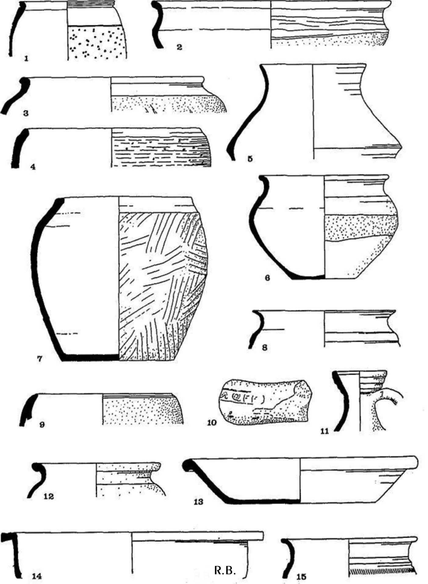
Coarse ware fragments were numerous and varied. Most were of standard types, but others may not have exact parallels. A selection is described and illustrated (Fig. 2, nos. 1-6, 8-10, 14 and 15).
- Rough-cast beaker with brown surface, cream paste and with cornice rim.2
- Shallow bowl with bead rim, brown fabric with grey core and black pigment on both surfaces.
- Coarse-textured cooking-pot, lightly burnished at neck.
- Coarse-textured, heavily gritted vessel with black burnished finish at rim. First century.
Footnotes:
1 The amphora was apparently made in the region of Spain between Cordova and Seville. The stamp MQFF (Calendar, no. 1165) indicates a date of manufacture between A.D. 120 and 160 (D. P. S. Peacock, pers. comm.).
2 J. P. Gillam. Types of Roman Coarse Pottery Vessels in Northern Britain, Newcastle-on-Tyne, Second edition (1968), no. 72.]
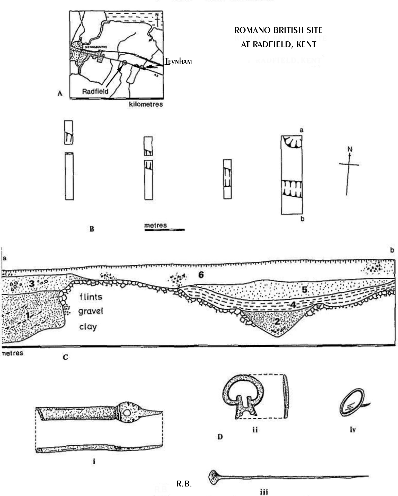
Fig. 1.
A: Map of Sittingbourne and Teynham, showing Radfield.
B: Layout of Trenches. The original trench is at the right (east).
C: Profile of the Features along the Section a—b. North is to the left.
D: Bronze small finds (Scale: ½)
- Fine-textured grey carinated pot with smooth surface. Common during second half of first century,3
- Cooking-pot with outcurved rim and cordon. Burnished, with band at belly left rough. c. AD. 120.4
- Fine-textured bowl with inverted rim, shoulder cordon and burnished outer surface. Grey fabric with lighter grey core. First to early-second century.
- Mica-dusted bowl with reed-rim and deep flange. Orange fabric,
grey core. First century.
- Mica-dusted dish with reeded rim. Orange fabric with grey core, A.D. 180.
- Fine-textured vessel in grey fabric with outcurved rim, cordon and pattern (rouletting?) of diagonal burnished lines at shoulder. Early second-century.5
The layer which sealed the pit (Fig, 1, 3) was sandier and contained flints. Roman roof-tile fragments, iron-stone and domestic animal bones and oyster shells were present. Pottery included coarse ware of first- and second-century date and fragments of samian. Of the latter one sherd depicted a hunting scene (Form 37?). Forms 15/17 and 18 also indicated a late first-century date.
B. The Ditch
Within the main trench this feature (Fig. 1C, 2) contained a yellowish sandy loam, interspersed with siltier deposits, and yielded bone fragments, including jaws of ox and horse. Roman roof-tile fragments, iron ore, and burnt clay fragments were found, as was the spring-pin of a Roman bronze brooch and a bronze disc-pin (Fig. 1D, iv). There were fragments of coarse pottery of a date no later than the late second century. Examples are illustrated in Fig. 2:
- Flagon with two ridged handle and four rings at neck. Cream slip on orange fabric. A.D. 140-180.6
- Pot of brown fabric with grey core and bead rim. Sanded surface. First to second century.
- Dish with squared bead rim, in grey fabric with burnished outer surface. A.D. 190-240.7
Footnotes:
3 See, e.g. B. Philp. Excavations in West Kent,1960-1970, (1973), no. 285.
4 See, e.g. J. Bushe-Fox. The Excavation of the Roman Fort at Richborough, Kent, iv. (1926), no. 467.
5 See P. J. Woods, Brixworth Excavations: The Romano-British Villa, 1965-70, Northampton Museums and Art Gallery, viii, no. 97, Also B. Philp, op. cit., in n. 3, no. 240.
6 Gillam, op. cit., in n. 2, no. 9.
7 Mid., no. 312.
Further excavation showed the ditch to extend at least 30 m. to the west of the initial trench (Fig. 1B) in a line parallel to, and 60 m. south of, the line of the Rochester to Canterbury Roman road located in the 1968-9 excavation. The ditch appeared too small for defensive purposes and too deep for mere local drainage. It could perhaps have served to retain stock before it became filled with animal carcasses and debris.
Over the ditch contents proper and in shallow depressions cut into the rim of the ditch at the west side of the trench were several deposits of darker soil, rich in oyster shells, bone and pottery. There was much evidence of fire; charcoal fragments, lumps of baked clay, pieces of worked iron, and several fragments of what appeared to be iron "slag". Possibly the partly-filled ditch had been used for iron smelting or working. Further pieces of Roman roof-tile were found. Bronze finds included a straight-pin (Fig. ID, iii), a 'buckle' (Fig. ID, ii) and brooch fragments. A bronze brooch with a perforated catch-plate and stylized but non-functional collar was found in this layer. It was very similar to a brooch from Swarling which was described as pre-Conquest but of more recent date than 84 B.C.8 There were four fragments of samian ware (mid- to late-second century, including a fragment of Form 31 stamped ] NI) and many fragments of coarse ware. The latter were mainly of the second century, but with sonic first-century fragments in one of the 'pockets' near the ditch rim. This last material was much worn and may have been brought in as 'fill' from elsewhere.
The contents of the ditch and associated minor gullies exposed by the excavation of trenches to the east of the main trench (Fig. IB) consisted of more animal bone, Roman roof-tile, and fragments of flagon, urn and cooking-pot of first- and second-century date. At one point just away from the rim of the ditch, and close to the original ground surface, was found an almost complete hand-made, comb-patterned grey ware vessel (Fig. 2, 7) very much in the Belgic tradition. In &similar position relative to the ditch but at a shallower level, a high tin-content bronze potin coin was found which bore the typical stylized Apollo head and bull. It appeared to belong to Allen's Class II, Type 0,2 (or possibly type P).9 A second British coin, of first-century B.C. date was found in the deposits overlying the ditch. Details of this coin have been reported elsewhere.10
Layers above the ditch, but below the layer disturbed by the levelling operation, contained Roman pottery, tiles, amphora; and a quernstone. Bronze objects included a twisted wire and a "bucket handle" similar in nature to a piece reported from Stone, Faversham.11
Footnotes:
8 J. P. Bushe-Fox, Excavations of the Late Celtic Urn-fields at Swarling, Kent, Oxford, 1925. Plate 15, 16d.
9 D. B. Allen, pets. comm.
10 R. Baxter, 'Coins from Radfield, Sittingbourne, 1972-3', Kent Archaeol. Review, 35 (1974), 131.
11 W. Whiting, W. Hawley and T. May, Report of the Excavation of the Roman Cemetery at Ospringe, Kent, (1931) PI. LLX.
DISCUSSION
It seemed from the evidence provided by this excavation, that the site was occupied from immediately before the Roman occupation until at least the third century. It is probable that the ditch and pit were dug in the first or early second century. The site is on high ground, and, although the clayey underlying deposits are impervious, the stone and gravel nearer the surface would have provided areas of good drainage. Surface drainage would have been aided by the use of ditches and their associated gullies.
The occupants of the site during Roman times were evidently concerned with livestock raising and iron smelting and working on at least a small scale took place somewhere in the immediate area. Numerous fragments of Roman roof-tile spoke strongly of at least one building in the vicinity, although no structures were detected on this investigation.
The pottery contained samples typical of a span from the first century to the third, and parallels were found to finds from other sites in south-east England and elsewhere. In some cases, however, exact parallels have not been found, and these may represent hitherto unclassified types. Evidence for post-Roman occupation was scant; only one medieval potsherd was found.
The site is on the Roman London-Dover road midway between Rochester and Canterbury and may have represented a wayside settlement of peasant farmers, perhaps engaged in metalwork and trading for the benefit of travellers to and from the Channel ports. It is thought that a hitherto undiscovered posting station (Durolevum) lies somewhere in this general area.
ACKNOWLEDGEMENTS
Thanks are due to Messrs. Leslie Doubleday, Ltd., for permission to excavate on Radfield Farm. The forbearance and co-operation of the bailiff, Mr. R. Booker, is also appreciated.
Appreciation is particularly expressed to Mr. A. Gidlow without whose help and enthusiastic hard work progress would not have been made.11
Footnote:
11 W. Whiting, W. Hawley and T. May, Report of the Excavation of the Roman Cemetery at Ospringe, Kent, (1931) P1. LIX.
The Society thanks Dr Baxter for his permission to reproduce this article.
You can read similar on-line research articles from the KAS website.